You may have heard of the “Great Loop,” a well-traveled nautical circuit that involves the Hudson River, the Erie Canal, the Great Lakes and the Mississippi River. There is a Great Loop Cruiser’s Association, and members can fly a special burgee (flag).
But there’s another loop, less traveled by, called the Down East Loop (or sometimes, the Downeast Loop.)
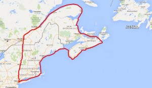 Simply put, instead of turning left at Waterford NY, and leaving the Hudson for the Erie Canal, this route continues up the Hudson, through the Champlain Canal and Lake Champlain, the Richeleau River, Chambley Canal, finally turning East at the St. Lawrence River. The only way home from here is around the Gaspé Peninsula, down the East coast of New Brunswick, through the Northumberland Strait past Prince Edward Island then the Canso Strait past Cape Breton Island. From there, the Loop continues along the East coast of Nova Scotia, ultimately ending up back in US waters along the Maine coast.
Along the way, there are many side trips to enjoy, weather permitting. The whole loop is almost 2,000 nautical miles. At a comfortable cruising speed of 7 or 7.5 knots, and assuming a 5-hour travel day, the trip could be completed in less than 60 days. But these waters are not known for making travel easy. Quite a few “in port” days are expected due to fog, winds, currents, high seas, local hospitality and sightseeing. Travelling for five hours, or 35-40 miles, sounds easy. And some days it will be. Other days it will not.
One of the most ambitious side trips, an option only if the rest of the trip goes better than expected, would be a short hop to Cape Breton‘s Bras d’Or Lake. And, a remote possibility, a crossing from the Northern tip of Cape Breton to Newfoundland.
60% of the Down East Loop is in Canadian waters, more than 1,200 nautical miles. Particularly ambitious loopers can extend the Newfoundland side trip to Saint Pierre and Miquelon, which are French territories.
Cygnus completed the Down East Loop during the summer of 2016, and kept a blog of the trip. To see All blog posts in chronological order, Click the Videos and Blogs link.
Above is an interactive map of the loop. Zoom, scroll or change the map background!
Mobile Users: Use the “Hamburger” button  above the map to open the menu for this site.
There’s also a similar menu button within the map for selecting map display options.
Thinking of going on the Down East Loop? Been there, done that? Leave a comment, below.
Good Morning,
We are considering doing the Down East Loop next year. Thank you for sharing your trip. What is the bridge clearance that we must make and where is it located?
Thanks,
Tim & Tawnya McNair
IT IS WELL
The lowest bridge clearances we found were in the Champlain Canal. The NY State Canal Corporate publishes the clearances at http://www.canals.ny.gov/boating/bridgeheights.html.
Note that the “pool” heights, and hence bridge clearances, are variable. So even though there could be as little as 14′, we never saw less than about 17′. And were were told that, if you call ahead, they can lower the pool for you. We didn’t have to try this, so I can’t vouch for it, and I don’t know how much advance notice they’d need.
How long is the longest distance needed for fuel I was considering doing the loop in a big center counsel. And staying at bed breakfast or camping where able.
Good question! Without knowing your range, I think it’s quite possible. My previous boat had about a 100NM range, with a gasoline engine, and went from the Hudson to Nova Scotia without too much problem. A couple of times I had to accept rides to the gas station from locals in far Downeast Maine and Nova Scotia. To Nova Scotia I carried four, six-gallon gas cans. They’re hard to find, most places only sell up to five-gallon portable tanks. That said, at least one of those two rides to gas stations could have been avoided if I’d just waited for the gas pumps to open in my original planned fuel stop.
Along the St. Laurence, Gaspe Peninsula and Northeast Nova Scotia are the most remote parts of this loop. But there are harbors every 50-100 miles, and most have fuel. A little research with some cruising guides, Active Captain and other online resources, would probably give you a working plan.
That same stretch gets a lot of tourism. We stayed at marinas which were also campgrounds, and saw many bed and breakfast facilities. Same with Much of Maine. So that part of the plan seems feasible too.
Hi, planning on doing the great loop next year and thought that we might carry on with the down east route when we got to New York, What time of year would be best to leave NY to start this trip?, and is it possible to go counterclockwise?
Good questions. I’ll answer the last one first. The clockwise direction helps a lot with the currents on the St. Lawrence, which is a good portion of the trip. Counter-clockwise is possible, and Capt. Cheryl Barr’s book The Down East Circle Route will give you some pointers on playing the currents.
The other issue gets into your question on timing. Clockwise, people start in NY around the time the canals open, normally mid-May. That gets you through the Northermost parts in mid summer. I can see one advantage to going the other way, which is that the weather along the East coasts of Maine and Nova Scotia turns windier as you get into September. There are still plenty of great cruising days through October, but they get fewer and farther between starting mid-September or so. On the flip side, you run the risk of hitting the closing dates for the canals if you’re going counter-clockwise.
I’m familiar with the current Canadian travel restrictions but just learned those traveling thru Canada enroute to Alaska are allowed x days to travel direct without side tracks. Huge fines for violating the rules.
Has anyone heard of exceptions for marine travel? I’m afraid boaters might be restricted to their vessels if even allowed to enter at all. Hopefully by spring of 2021 this will be resolved and a non-issue any way.
Wow so interesting. I would love to take this trip on my sea ray boat. I bought it last summer but didn’t have a lot of opportunities to travel on boat. So I think it’s a sign that I’ve found this article.
Hello, Our boat is too tall to do either the Great or the Down East loops. We will do in in segments and eventually switch boats to finish. This year we plan on doing the Hudson and the upper East Coast up to Bar Harbor. I am looking for the best books/info on navigating though Maine.
Thank you!!!
We have cruised the Maine coast for 20 years and find the “the cruising guide to the Maine coast” https://www.mainecoastguide.com/ extremely helpful.
Hello,
I am on Inspiration an Island Packet 350 sail boat. I am still a wannabe downcast looper.. In 2022, We made it to Rimouski and had a transmission failure. I recieved a permit from the Canadian Government to leave Inspiration in Rimouski for the winter. In 2023, ny wife could not travel and I put a crew together and brought Inspiration back to Chaumont, NY. In 2024 we tried again. The engine failed and put a rod through the oil pan about 5 miles west of Trois Rivieres. So its September and we have just made our way back to the 1000 Islands and eventually to Chaumont fro 2024 winter. It is possible to Navigate the St.Lawrence from the North East to South West, going upstream.
From the ocean to Montreal, the tides will help. generally, the rule is leave at low tide and use the flood tide to assist in the journey. It is almost as good as using the tide to assist going down stream. The rate of change of the level of the water is least at the high tide and low tide. There is about a 1 or 2 hour window before and after high and low tide when you can travel against the tide. The flood tide arrives later at each location as you travel upstream. So I would always note what time the high tide was at my destination. Travel upstream gave more travel time for this reason. My rule for going upstream was to leave at low tide but sometimes a little earlier. Plan to arrive by high tide or no later than 1 hour after.
Two exceptions were leaving Tadoussac and leaving Quebec City. The Saguenay Fiord is still emptying when the St. Lawrence is at low tide. This can create severe eddy currents. I leave 2 hours after low tide with plenty of time to get to Cap A L’Aigle. Low tide at Quebec City, in combination with the current of the St. Lawrence, can create eddy currents under the bridges at St. Foy as it is the narrowest part of the river. So the rule is to leave Quebec City 2 hours after low tide to give time for the flood to give its assistance under the bridge.
In the St. Lawrence Seaway, from Montreal to the beginning of Ontario, the lakes formed behind the dams and locks help to provide less current. Then the last part of the river through the Thousand Islands is just a little slower against the current but it can be done. I averaged about 5.5 knots through the Seaway and 5 knots through the Thousand Islands.
Next year, I hope to restart my journey again and to make it to Nova Scotia and on to Maine.